Mapping the Landscape of Conjecture
Expanded Site Characterization Project
Compiles Disparate Source Material
The expanded Site Characterization project known as The Landscape of Conjecture entails mapping the Nellis Range Complex, a restricted military area in Nevada the size of Connecticut. The map being created at The Center includes speculative as well as actual features of the landscape. The source material for the map is coming from a wide range of perspectives:
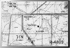
- The Air Force Range Map, produced for pilots and other military personnel
associated with training exercises performed there emphasizes the features
of the landscape significant to their activities. This part of the chart shows the Tonapah Test Range area.
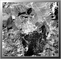
- Landstat 5 Satellite-Image maps are not truly photographic, but reveal many features of the landscape that maps leave out. At the center of thisLandstat image is the Tolicha Peak facility within the Nellis Range.
- The 1970's series of USGS maps show more man-made features on the range than subsequent editions of the maps. The long Groom Lake runway, for example, disappears on the next edition of these maps, which are intended for the general public.

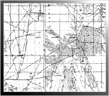
- Maps from independent sources are often informative. Above is one in a
series of three maps of the Groom Lake facilities, created by the Area 51
Research Center. The Air Force still refuses to acknowledge the existence
of any facilities at this location.
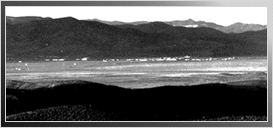
- Both aerial and land-based photographs are another source of information
for the project, such as this photograph of the "non-existent" Groom Lake
facilities, taken from a hill top that has since been removed from public
access.
 Return To UFO Information Menu.